Land Library Search
Through our robust search engine, you can search for any item of the over 73,000 highly curated resources in the Land Library.
If you would like to find an overview of what is possible, feel free to peruse the Search Guide.
/ library resources
Showing items 1 through 9 of 16.
Research hypothesis: research of cadastral assessment models makes scientifically basic for purposeful improvement.
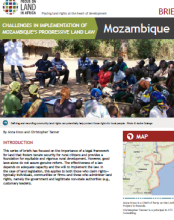
This series of briefs has focused on the importance of a legal framework

To determine the agricultural crops productivity on reclaimed areas with the adjusted water regime it is offered to use the point estimation of ground fertility and standard report data on different areas actual productivity (ploughed field, hayfield, pasture).
The cadastre structure in the system of land and real estate management is determined by existing and technologically dependent kinds of works and procedures on registration, recording and valuation of real estate.
Writing topics actuality is based on the government proposed property tax increase of 2011 residential tax.
In order to ensure operation of the Cadastre, the Cadastre information system is being maintained and improved. Cadastre text and spatial data regarding cadastre objects, which are located in the territory of Latvia, are registered and maintained in the Cadastre information system.
The purpose of the present Law is to lay down rules aimed at the establishment of the infrastructure for spatial information in Upper Austria with a view to environmental policies and activities which may have an impact on the environment.
The purpose of the present Act is to transpose into national legislation the Directive 2007/2/EC of the European Parliament and of the Council of 14 March 2007 establishing an Infrastructure for Spatial Information in the European Community (INSPIRE).
La présente circulaire définit l’instruction concernant la procédure à suivre en matière d’ouverture des Guichets Fonciers Communaux ou Intercommunaux.