Land Library
Welcome to the Land Portal Library. Explore our vast collection of open-access resources (over 74,000) including reports, journal articles, research papers, peer-reviewed publications, legal documents, videos and much more.
/ library resources
Showing items 1 through 9 of 717.
This guide takes communities and their leaders, and 'ocal and national civil society organisations, through the steps needed to ensure that land investments in the community are carried out inclusively and responsibly.
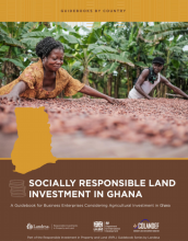
The Business Enterprise Guidebook aims to help companies and investots understand how to facilitate a responsible investment in Ghana.

This Guidebook for Business Enterprise includes instructions and tailorable tools for business professionals seeking to design and implement an agricultural investment in a socially responsible manner that recognises and protects community land rights.

The Landassess Tool is a risk assessment and management framework. It provides a clear and simple set of checklists that generate a report to help companies assess and manage how they respect land rights.

The Social License Platform (SLP) matches businesses with the services and expertise they need to ensure that investments in agricultural land create growth opportunities for both business and local communities, while respecting the land rights of the communities that use the land.

This guidance aims to provide companies with an overview of the links between land and human rights enshrined in these agreements and in official statements issued by treaty monitoring bodies.

The dynamics of urbanization and growth of the Latin American city is due to different geographical, economic, and social factors.
Low productivity cattle ranching, with its linkages to rural poverty, deforestation and greenhouse gas (GHG) emissions, remains one of the largest sustainability challenges in Brazil and has impacts worldwide.
Determina el cambio en el uso de la tierra y la fragmentación de las zonas boscosas en el Corredor Biológico Lago Arenal Tenorio (CBLAT), en el periodo 2000 – 2017. Se utilizó imágenes del programa Landsat, a las cuales se les aplicó corrección radiométrica y atmosférica.