/ library resources
Showing items 1 through 9 of 6215.
In this study, a knowledge-based fuzzy classification method was used to classify possible soil-landforms in urban areas based on analysis of morphometric parameters (terrain attributes) derived from digital elevation models (DEMs).

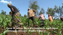
La terre a toujours été un bien très contesté. Le contrôle des terres et des ressources liées reflète les relations de pouvoir d’une région, d’un pays et constitue un indicateur des injustices sociales existantes.

Amid climate change, biodiversity loss and food insecurity, there is the growing need to draw synergies between micro-scale environmental processes and practices, and macro-level ecosystem dynamics to facilitate conservation decision-making.
The recent decades have witnessed a significant increase in the population in peri-urban areas which led to a progressive transformation of peri-urban landscapes, and the reduced ability of agriculture to provide ecosystem services.
Drastic growth of urban populations has caused expansion of peri-urban areas—the transitional zone between a city and its hinterland.
Street trees, native plantings, bioswales, and other forms of green infrastructure alleviate urban air and water pollution, diminish flooding vulnerability, support pollinators, and provide other benefits critical to human well-being.

The disparity in land and food access in Ghana often overlooks the possibility of an underlying gender disparity.
Land Library Search
Through our robust search engine, you can search for any item of the over 73,000 highly curated resources in the Land Library.
If you would like to find an overview of what is possible, feel free to peruse the Search Guide.